National Bicycle Greenway
The Route Explained Live at BikeRoute.com!!

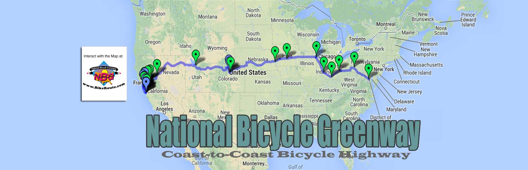
This is a description of our on-line map, along with a perfect world visualization of what is possible in some of the sections we travel through. As an anchor route, in time the other Greenway connections that will be added will become a part of a network that will feed it. As it travels from one city, one region and from one ocean to the other, our coast-to-coast bikeway will take on different characteristics that will require the different traffic calming devices we will suggest.
As we move through the 16 NBG Anchor City metros between San Jose/San Francisco/Oakland and Washington, DC, these measures will include bollards, green asphalt, protected bike lanes, Greenway signage, and parking and center turn lane removal, etc. Year in, year out, as cyclists travel the roads and paths we have identified, the city mothers and fathers along the way will begin to understand the value that our NBG Anchor City cyclists bring to their city. And as we help them to see the enhanced quality of life their own bike riding public also brings about, not only will the improvements we are calling for find expression, but so too will the dedicated bicycle highway we long have envisioned.
In time, we foresee that the NBG Anchor Cities our cyclists will be traveling through will be made very attractive with the NBG Hubs we envision. Reconverted warehouses, each of them will be filled with a large meeting hall, bike museum, bike repair stations, a library/computer/yoga room, recycled bicycle showroom, a bike taxi feet, a human powered power plant, shower facilities, lockers, a recharge room and mail room as well as office space for other bike and environmental organizations. In getting to them, the green asphalt, consistently emblazoned with the NBG logo of protected bike lanes, set off from vehicles by regularly positioned bollards, will clearly mark the path.

The San Francisco/Oakland Bay Bridge Bike path from Treasure Island
Where possible in our NBG Anchor cities, we are also hoping that besides their different colored section of the road, the lanes our cyclists will use will also be clearly marked with handsome and colorful, slightly oversize street signs. NBG green in color, the black print will regularly advise the NBG traveler of distances to the various destinations along the way. Every mile a different set of signposts will appear.
 Our NBG route across America begins near Lake Merritt (America’s first wildlife sanctuary) in Oakland. In 1884, it was from Oakland that Thomas Stevens set off on a HiWheel bicycle to become the first man to use his own power to travel across a continent when he arrived in Boston 103 days and 3,700 miles later. Though much of the pomp and circumstance for Stevens’s ride occurred in San Francisco, he had had to cross the Bay in a boat before he could begin pedaling to the East Coast. As such, grand Oakland City Hall will be the symbolic start of our ride.
From Oakland and then Berkeley, on a mix of well-striped and fairly well-signed surface streets and bike paths, we head up to the Carquinez Bridge. On lands where oil refineries occupy prime real estate along the Bay for well over half of this part of the trip, we will pass through Albany, El Cerrito, Richmond, San Pablo, Pinole, Hercules and Rodeo.
From the Carquinnez water crossing, a lot of the work the city of Vallejo has done for bike travel along its waterways will greet our riders before we head next to Napa City Hall. Instead of riding the vineyards of the Silverado Trail north all the way to Calistoga, coast-to-coast cyclists will make a several mile U-turn that places them on CA-121, also known as Monticello Rd, as they point their handlebars toward Davis. The 50 miles ahead are made up of the mostly wide-open lands and country roads that lead to Sacramento’s next door neighbor city.

The Yolo Causeway
As such, with the exception of clearly marked roads, little infrastructure work will have been needed between Napa and Davis, the home of America’s first bike lane. Our next destination will be Sacramento, 15 miles away. Where the route to it runs adjacent to I-80, a plexiglas sound wall will hopefully have been built that shuts off much of the noise from the busy Yolo Causeway as the Interstate is known at this point. To additionally make this five-mile stretch enjoyable, instead of the nerve grating experience it long has been, during the summer, we have suggested that misters be installed to keep our cyclists from overheating in the 90+ degree average temperatures.

From the CA state capital city, the bicycle heaven of the American River Parkway <described at this link> will take us to Folsom, thirty miles away, at the foothills of the Sierra Mountain Range. Wise stewards of the Jedediah Memorial Trail as the Parkway is officially known, Folsom also has many miles of trails of its own. From there on gently rolling country roads, our riders move to historic Placerville.

Here, Hwy 50 greets them. A busy freeway through this still quaint town, it tames down to to a two lanes of travel in each direction when it leaves it. A breakthrough road, this was how the Lincoln Hwy, America’s first coast to coast motor way <described in Martin Krieg’s book, “How America Can Bike and Grow Rich HERE> got over the Sierras nearly a hundred years ago.
For the next 50 miles, the road climbs at an average grade of 6% to Echo Summit at 7,382 feet. Here, instead of continuing on historic 50, our cyclists turn left to descend on Old Meyers Grade Road into the small town of Meyers at the southern end of the Lake Tahoe valley.
After descending into the post card beauty of Lake Tahoe, spread out before them for miles and miles, once our bike riders reach Meyers, they will not have far to travel before they are reunited with US-50 and the picturesque resort village of South Lake Tahoe, a LAB recognized town of 21,000 people. After enjoying South Lake, they will travel on well-signed roads mostly bordering pine forests before the road then climbs the 7,780-foot Spooner Summit up and out of the valley. As the forests begin to thin, one has to wonder how many people are aware that this area is named after the French Canadian entrepreneur, Michele E. Spooner who stripped it of its beauty. Spooner was instrumental in establishing the wood and lumber industry which for almost 30 years, at the end of the 19th century, took so many trees away from these lands.
From the summit of US-50, a lightly traveled freeway at this point, a long ten-mile descent begins. We would like to see this outfitted with a bike lane protected by a rumble strip and green and black fiberglass bollards. It ends 3,000 foot lower on the outskirts of Carson City, the Nevada state capital.

From Carson, a small amount of climbing through desert sage brush takes Greenway cyclists on roads which can easily be well signed for the NBG, to the shores of Washoe Lake, a huge body of water that seems out of place in its surroundings. As cars and trucks make their way along I-395 on the huge lake’s western side, three miles away, for six miles there is hardly a vehicle to be found on the two-lane road we pedal. Turning back and forth to follow the contour of the lake, all this leads back to the interstate that cuts through the foothills that block the imposing Reno skyline.
Until our cyclists can use five miles of an I-395 that will have been made safe for cyclists, they will have to use a mix of moderately traveled roads to get over the grade before them before they then descend out of the small hills. For the next 14 miles, the route travels on a few different two-lane roads that cut through the high desert sagebrush. As the Reno downtown slowly grows in size, the road to it fills up with more and more businesses, driveways and cars. In the future, we are hoping the cyclist can let his or her guard down as we foresee a wide bike lane protected by a tiny island of concrete which tells motorists who has the right of way out here.
The true oasis of the Truckee River and it’s Car-Free bike path awaits our cross country cyclists once they reach downtown Reno. After re-provisioning themselves at the edges of town, NBG cyclists will use what, in the summer months, looks like a dried up creek bed for eight miles to get across Reno and Sparks to I-80. On the pathway dikes that contain wintertime mountain snow melt, our riders will amble in and out of the occasional lush, green grounds of the several parks along the way.

On a freeway shoulder very wide now but that we hope will be built to NBG spec, we will ride 35 miles to the town of Fernley, where NBG cyclists will choose which route they want to take across Nevada, America’s most mountainous state and its seventh largest in terms of land mass. They can stay on the more gently graded interstate or follow Main St out of Fernley, which becomes US-50 again, here known as the Loneliest Highway (blog description from “How America Can Bike and Grow Rich”) as it crosses the state. On this road, beyond Fallon 27 miles away, they head next for the historic, once bustling silver mining towns of Austin, Eureka and Ely.

For those cyclists who instead of the Loneliest Hwy, choose the less challenging climbing of I-80 there is a cost. Once they reach Wendover at the state line they must cross the fully barren Salt Lake Basin that stands between them and Salt Lake City. HERE is the monstrous challenge I faced when I did this ride in 2009.
I averaged seven miles an hour on my HiWheel, the Eagle, for 101 miles between any kind of services/stops for food, water, shade or rest. I did so in 90-100° heat with cars passing me at 80 to 100 miles an hour. And yet because there is so much real estate between both directions of travel (several hundred yards), what I suffered through can be turned into a bicycle heaven.
In time, we would like to see this route made a lot easier with a bike path that can easily run twenty feet away from the freeway in both directions of travel. In addition, this escape from the noise and danger of high-speed vehicles can also be outfitted with NBG Rest Stops. At these bicycle sanctuaries, our cyclists can re-hydrate themselves as well as procure emergency supplies at the NBG vending machines we foresee.

On this 101-mile stretch of high-speed roadway, where there are NO SERVICES, it is our NBG Rest Stops that can offer enough relief to make this harsh piece of geography negotiable for a greater number of bike riding fitness levels. In time, as our cyclists continue to bring life to these desolate lands, we foresee regular drinking fountain installations along the way, as well as camp sites and overnight accommodation in the middle of the Salt Lake Basin. For now, however, we are hoping a sag wagon will travel back and forth, once in the morning and once in the evening, from April to October, to shuttle riders who are unwilling to ride the whole basin in a day.
The grueling conditions and sameness of scenery will give way to civilization once the bike traveler reaches the mammoth truck stop that predominates the town of Lake Pointe, the first town at the edge of the desert. Most will want to call it a day here, where they can find food and lodging, even camping, The several convenience marts they will find here that cater to the needs of the truck driver now also service many of the needs of the long haul bike rider.
Still 30 miles from Salt Lake City, our riders will need to get back on I-80, much busier at this point, for another seven miles until they reach the UT-202 exit. They will use it to get to the other side of the freeway where clearly signed, little used frontage roads will take them well over half of the way to downtown SLC. In the light industrial lands that greet our cyclists as they get closer to City Hall, we would like to see the signage become more conspicuous to also remind motorists to keep cyclists in mind. Here we also hope a bike lane will also have been added with green asphalt in some of the short stretches where there are a lot of cars.

Attention to signs will no longer be necessary once N. Temple is reached. A wide, lightly traveled boulevard, it climbs gradually up to the Mormon Temple, nearby City Hall and the center of the city. All of this is set on a ledge at the base of the Wasatch Mtns.
In moving on, NBG cyclists can choose the less strenuous but busier I-80 path that will take them to Laramie in Wyoming where they can drop down to Boulder, Golden and Denver. Or they can ride the Jordan River Parkway Trail for 38 miles to the city of Lehi. From there a couple dozen well signed rights and lefts will take them 14 more miles to Orem before they turn up the Provo Canyon into the mountains.
From Heber City, they will get on US-40 and stay on it as far as the Colorado border. In time, we are hoping this Utah part of the old Victory Hwy, will have been outfitted with an improved four-foot shoulder as well as strategic NBG signage placements to turn these Utah mountain lands into a booming summer time bicycle paradise that will have placed the popular Strawberry Lake recreation area (elev. 7,602) on the national bike radar. As services such as juice bars, snack shops and bike repair huts crop up in the small towns of Currant Creek, Fruitland, and Duchesne, hiker/biker cabins and campsites will also have been developed at the lake itself.
 From Vernal in Utah and then Dinosaur, just inside the Colorado border, US-40 now offers the huge skies of a gently sloping high desert terrain. It won’t be until the picturesque town of Steamboat Springs is reached and US-40 leaves town, that the climbing of the Rockies will have begun in earnest.
After ascending Rabbit Ears Pass (elev. 9,436), with a tiny shoulder now, but soon hopefully outfitted with a generous bike lane, the small mountain towns of Kemmerling and Granby give way to the base of the highest highway in the world, Trailridge Road.
A spectacular 20-mile climb from Granby Lake (elev. 8,367), made rideable by switchbacks, gets us to the 12,183 summit.


From there, the road drops almost 5,000 feet on a very fast 27-mile descent with wide sloping turns all the way to Estes Park (elev. 7,522).


For 37 miles the roads continue to drop two thousand more feet to Boulder, an NBG NBG Anchor City and the home of the world’s first Bike to Work Day. Getting across Boulder is easy thanks to the labyrinth of Car-Free bike paths that exist there. We will use them to get to CO-93 that runs all the way to Golden. As the home of the largest brewery in the world, Coors, Golden, is an outdoor recreation paradise. It is also rated as one of the top most livable cities in the world and has had a long history of proactive bicycle leadership.
We get back on US-40 for the trip to Denver 15 more miles away. In the Mile High city, the State Capital and Denver City Hall are less than half a mile apart. From here, our riders will need to ready themselves for lots of riding, because our next NBG Anchor City, Omaha is over 550 miles away.
A regular succession of lefts and rights will work NBG cyclists through a mix of suburbia and brown treeless farmlands, on their way to northeast Colorado. To help them do so, we are hoping that in time, all the roads they will be on will be clearly marked with the familiar, green and black, NBG signage.
About a hundred miles from Denver, our riders pass through the more desolate, ranching lands east of Sterling, CO. It is this kind of riding that will continue for another 70 or so miles until they reach Venango, inside the border of the next state we pass through, Nebraska.

Almost as if walking on to a different movie set, upon crossing the state line, the green of agriculture breathes life into what feels like a world of new beginnings. 38 miles later, from Ogallala, our NBG cyclists will be reunited with the Lincoln Highway, known as US- 30 at this point, where generous bike lanes will take them on flat roads through oceans of corn and soy bean fields all the way to Fremont, 30 miles from Omaha City Hall. From 30, in time, well-signed roads will get them into the center of the huge breadbasket city of Omaha.

In Omaha, once the outer edge of the East Coast and a point of debarkation to the West, separated from the state of Iowa by the Missouri River, our cyclists will then travel over it on the Bob Kerry Pedestrian Bridge. Three thousand feet long and 27 feet wide, since 2008, this important water crossing has been moving coast-to-coast bicycle travelers further north away from the hotter, drier, less interesting roads of Kansas.
 Once on the Iowa side, the farm roads become short up and down hill work for 156 miles on the way to our next NBG Anchor City, Des Moines. We are hoping that, in time, a paved, wide shoulder will be added to double as an NBG bike lane as well as a slow moving vehicle lane for all the farm machinery needed to work these lands. This will serve as a propitious addition for the people in all the many towns along the way. Set at 15 to 20 mile intervals, the small population centers along the way will all come to love the peace and prosperity that bike travelers will have brought their way.
Besides the food and drink concessions we foresee some Iowans making available for our NBG cyclists, bike repair shops and roadside B&B’s will also be a common occurrence between Council Bluffs and Des Moines. Once in Des Moines, the many off street bike paths will all be clearly marked to get the NBG traveler into town. At 207,000 people of its own, as the command center for RAGBRAI, the week-long annual ride across Iowa that brings many thousands of cyclists to the state, Des Moines knows the value of bike riders.
Des Moines is an easy city to cycle in because traffic is a virtual unknown and bike paths are easy to find. From it, our bicyclists will ride to Chicago, the same way they came in – on bike paths. Once back on roads, 250 miles worth of hilly Iowa roads later, after crossing the Mississippi River in Davenport on Government Bridge (also called Arsenal Bridge) they will move into Rock Island and the state of Illinois. The largest island in the Mississippi River, at 39.000 people, Rock Island is home to the biggest government-owned weapons manufacturer.
 Soon Hennepin Canal trail and its 115 miles of bike trail heaven will take our riders to Rock Falls, IL and the well-signed NBG roads that lead to La Salle on the Illinois River. At this point our cyclists reach another Car-Free towpath, the Illinois and Michigan Trail. Along the I&M, markers regularly articulate the history along the way. We are hoping that National Bicycle Greenway signage will soon join the interpretive nature of this part of our ride.
Once in Chicago, bike lanes and infrastructure improvements that favor the cyclist lead through much of the the city. When our cyclists are ready to move beyond bicycle aware Chicago, they will next move to Indianapolis, the home of the National Bicycle Greenway and the best biking downtown in America. To get there, they will leave the Lakefront Trail on Lake Michigan and follow a mix of trails and paths for 75 miles before they reach LaPorte, Indiana. There they will reach Indiana’s first interconnected bike route, made up of lightly used US highways, USBR 35, which will take them to Indianapolis.

Indianapolis Aerial
In the Greenway Capital of the World, one can enjoy the only downtown greenway on Planet Earth, the Indianapolis Cultural Trail <link to NBG slide show> and the storybook Indy Canal. In doing so, they will have arrived on the world class Monon Trail. At 28 miles, the award winning Monon is just one of the many paved pathways that radiate out from the most bikeable downtown on Planet Earth.


Indianapolis Riding Turf
To get next to Columbus, our riders will use the old National Road alignment which first traveled through Indiana in 1829. Usurped by US 40, as a US Highway, like all US highways, it offers good sight lines, a graded roadbed (eliminating up and down hill work) and enough shoulder to make it fairly comfortable. Because it has been, itself, usurped by the interstate, I-80, most parts of it feature light traffic.
In time, all of the high speed roads on our route will be upgraded to the National Bicycle Greenway spec. The shoulders will be made wider and where applicable bollards will be put in place to separate cars and bikes, etc..

On our way to Pittsburgh, US-22 roughly follows a section of Zanes Trace, a frontier road that dates back to 1796. It was then that land speculator Ebenezer Zane got Congress to finance construction of a 230-mile right of way. Building it, involved a lot of tree and stump removal in the heavily forested southeastern quarter of what would become the state of Ohio.
From Steubenville, a tiny but historic town of only 18,000 people, on the state’s eastern border, at the Ohio River, our bike riders will cross it on the 1,794 foot long Market St Bridge. A renovated steel bridge, this water crossing was built in 1905 to carry cars, carriages, horses and people over the river at a time when only trains could do so on the nearby Panhandle Railroad Bridge built almost a half century before in 1857.

Heinz Field, Pittsburgh
On the way to beautiful Pittsburgh, the roads and 40 miles that remain will all, in time, be well signed with NBG markers. The forest covered hills that our riders look out upon will grow richer and greener as the storybook Pittsburgh skyline begins to come in to view. The fact that the entrance to the Gateway Trail to the East Coast lies not far from all the shimmering glass and steel that lies ahead adds magic to our arrival.

Mount Washington, Pittsburgh
From Pittsburgh, now an emerald jewel in the Allegheny Mtns, with air once so dirty it was called ‘hell with a lid on’, our riders finish their trek across the USA on a travel corridor that traces back to the birth of our Nation. In fact, the first 141 miles are the general alignment a young George Washington used in 1754 and in 1755. In traveling from Cumberland, Maryland, it was then that he used Nemacolin’s Path, an old Native American trail, over the rugged Appalachian Mountains to get to Fort Duquesne. It was there that he tried to get the French to leave the the tip of the three present day Pittsburgh rivers, the Allegheny, and the Monongahela which become the Ohio River.
Later when iron ore was discovered in Pittsburgh, it needed coal for its steel making furnaces. Soon, the B&O (Baltimore & Ohio) Railroad began bringing it in from Connellsville, PA. 70 miles to the east, Cumberland was also rich in coal. Once again, the B&O was busy shipping it the other way, to Baltimore where the people of the East needed it to heat their homes.
In 1912, when George Gould built a rail line next to the part of the B&O, that connected Cumberland and Connellsville to Pittsburgh, he made the Car-Free GAP (Great Allegheny Passage) trail that cyclists enjoy today possible. Though Gould failed after a few years in his attempt to form a transcontinental rail line, his train tracks stayed active until 1982 when the last of the mines they served closed down. In 1991 work began on the present day bicycle passage way.
As a former railway, it is easily bikeable. This is so because in order for trains to function in mountains, the grade cannot exceed 2-3%. To achieve this here, similar to what the B&O did, Gould still had to bore tunnels and add dirt to remove all the up and down terrain that stood amongst all the many summits along the way. The long, slow climbs and descents that resulted are perfect for pedaling. And this is what the Great Allegheny Passage has become – a great place to ride a bicycle!
In traveling through this corridor, just a few miles away from where the National Road (now US-40) still makes its way through these lands, our cyclists are rewarded with even more magic when they reach Cumberland. It is here that they get on the C&O Canal Towpath that 185 miles later takes them to Washington DC and the end of our ride.

Nor is there a better way to reach our Nation’s Capitol than to come in on it from the history laden C&O. Built on the banks of the Potomac River, it was engineered in 1831 so that horses could pull barges usually filled with coal (90% of the cargo) down the windy river from the Allegheny Mountain mines. As such, the path is virtually a flat one.
In getting a feel for all the work that was done to make this water way navigable, our cyclists will marvel at all the locks, tunnels and bridges that were built almost 200 years ago just to move coal. Nor can the Civil War battlegrounds that appear along the C&O Canal Towpath be ignored by the time our cyclists reach Washington, DC. As the dividing line between the north and the south, many battles were fought along its edges which markers commemorate today.


In our final NBG Anchor City, our cyclists will have arrived in a city that is an alternative transportation leader. Fed now by the C&O and the Anacostia River Trails that bring East Coast, long distance two-wheelers to it, the Nation’s Capitol is telling America it places a high value on its bicycle guests. Add all the miles of bike lanes and other infrastructure improvements it continues to make and one can see that instead of financing road building efforts such as Zanes Trace, the National Road, the US Highways and The Dwight D. Eisenhower National System of Interstate and Defense Highways (the Interstate Highway System), that Washington DC now knows it is the bicycle that can help reconnect us to our bodies, our brothers and a Nation that our transportation choices have so disconnected us from.

When I rode a bike from CA to Washington, DC in 1979, I was looked down upon as an unfortunate soul who could not get it together to own a car. I stood at the Washington Mall feeling both triumphant and sad as I watched the cars on all the roads around me busily scurrying about. I wondered if there was anything i could do to show people how much richer their own lives could be if they replaced car trips with bike trips. I knew they would understand the worth of my accomplishment if they left their motor vehicles behind.
THX 4 all of U!!
Martin Krieg
You must be logged in to post a comment.