
The site we choose for Bicycle Route Planning will establish it as the Bicycle Route Planning site for the National Bicycle Greenway and cause many cyclists to pick it over another. It will help them feel that by supporting such a platform they are part of the effort to build our coast to coast bike route.
The Bicycle Route Planning site we choose (there are over 30 of them) will be embedded at BikeRoute.com as well as have a marquis presence at their website. At it, there will be a link to our organization as well as a short description of our vision statement and, of course, a map with our coast to coast route on it. In addition, bolded out text will read,
“Help us build the National Bicycle Greenway.”

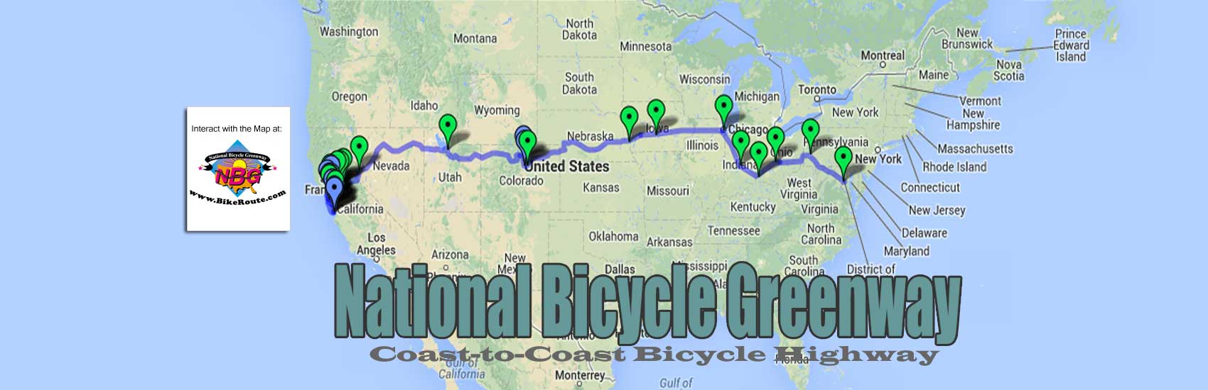
Under the above graphic, will be the city to city navigation links for which the site we work with will be asking for information. Going East to West, since Washington, DC to Pittsburgh, PA is known in the form of the Great Allegheny Passage/C&O Canal trail, the first line items will read –
East to West: Pittsburgh to Columbus | Columbus to Cincinnati | Cincinnati to Indianapolis | Indianapolis to Chicago | Chicago to Des Moines, etc
All the way to San Francisco. Whereupon the linked text will change to read –
West to East: San Francisco to Palo Alto | Santa Cruz to San Jose | San Jose to Palo Alto | Palo Alto to Oakland | Oakland to Napa | etc
From either direction, when any of these Anchor City connecting routes are clicked, here is the text that will result –
“Thank you for your interest in helping us to build America’s first coast-to-coast bicycle highway. In getting from one NBG Anchor City to another, when you click on any of the connecting routes above, the route that appears is what the nonprofit National Bicycle Greenway is suggesting to make this connection. If you can suggest a better travel route, or improvements to the one you see here, you can become a part of the NBG Rock by clicking on any of the above connections you would like to change.
The page that comes up will be the Google route that you can alter. You can place your cursor on any of the roads you want to change and drag them accordingly. Your changes will be shown in red. There will also be a button you can select to load a completely different route.
Here, there will also be forms you can use to embellish what you are suggesting. It will also be here that you can add comments and pictures as well as any businesses and/or sights to see/places of interest (you can do this for any of our routes). Those interested in helping us flesh any of our routes out with pictures and/or notable stops, can also use these forms and do so without changing the roads.
It will be any changes you make that will subject them to a vote. Toward that end, at the end of every riding season, if the roads (and/or paths) you propose are seen as more favorable than others, they will get built in to the NBG’s suggested way to make this connection.


In the end, on a computer screen, we want our SF to DC route east to west across America to look like the USBR 35 route that travels south to north, up and down Indiana.
This information will be used to mark our route on the actual ground. Once we have validated our route online, we can start announcing our plans, beginning in population centers, to enhance two-block sections every 10 miles. Through community meetings and other means, the landscape architect firms we will have selected will professionally and convincingly, present the possibilities for each ten-mile marker section.
What follows will be shown when <more> is clicked:

Before any roadway improvements begin, the above is the methodology we will use to get mile-marker posts in the ground well before the upgrades we propose begin. Once posts do get placed, they will give authority to the message our landscape developers will have conveyed. Visualized as handsome, 4-foot tall, steel reinforced concrete posts, like what America’s first coast-to-coast highway, the Lincoln Highway, deployed, their symbolism will be strong. They will communicate the vision of connectivity, economic development, health and fitness, quality of life and how we will, in time, be connecting this alignment to destinations for recreation, historic sites, education, wildlife and adventure as well as internet and infrastructure possibilities.
As they formalize our route, they will also become revenue generating tools for all the programs they will become a part of, such as –
On the ground:
NBG Mile Marker logos & renewals
Greenway route signage
NBG Passport License sales
Corporate sections
On the internet:
Flagpost Map listings
Display Ads on
Maps
Anchor City Biking Report Cards
BikeRoute.com rider blogs
Mtn Mover Podcasts
NBG Anchor Cities
BikeRoute.com certificates like Camino de Santiago compostelas riders can use to TransAm spaced over several years
All of these revenue streams will be discussed in NBG Director, Martin Krieg’s, new book about how we will make the National Bicycle Greenway real.
——————————-
In terms of our California NBG Anchor cities, we have had a lot of experience with the roads and paths that connect them. As such, these are the ten connections we show on our maps.
At them, you will see that there are two starting points. San Francisco and Santa Cruz. In the case of San Francisco to Palo Alto, starting at San Francisco City Hall (all routes start and end at City Hall), the route that appears is a bike route through the San Francisco Peninsula cities. Based on the annual rides we used to do between these two NBG Anchors, this is what we feel is the best way to make this connection.
Santa Cruz to San Jose has also been much tested. A former 20-year resident of the ocean side city, Krieg has much explored the many different ways to make this connection. And yet none of the roads and paths that enjoin our Anchor cities are perfect. That is why we are asking the cycling community to help us tweak them..
Alternative routes are also welcome. If someone wanted to ride along the ocean to make the SF to Palo Alto connection, for example, there will be a button they can click to suggest their alternate route. Alternate routes will always appear (with its author) along with the NBG suggested route. On the other side of the Bay, Oakland to Napa can be used to illustrate such variety. There are many routes through the beautiful Oakland hills one can use to make this connection. They all take more time, offer far fewer services and require higher levels of cycling skill, but they can appear as alternate routes on our map.

I had the vision that filled Indianapolis with Greenways, but there were thousands of people who shared that vision. It was they who cleaned up our White River and streams, that helped plan, worked to raise money, volunteered countless hours and followed the plan we all created with something very special for our City that became a model for the Nation. But until I opened the door for others to join the effort, share the vision, give their ideas, and help design the plan, it was a mute dream.
Every development department in every city has countless plans that have gone nowhere. Why? Because no one ever took it on themselves to breathe life into the plan or was empowered to see that the plan got done. So creating a plan is just one step, it takes someone to tirelessly lead that effort, and engage others to join the effort making it their trail, their Greenway, their bridge, their idea.
It is here that I feel as the Director of the National Bicycle Greenway, Martin Krieg is the guy who can can lead the charge that will connect the coasts with a bikeway that will in time become a Greenway. I have watched his work since the 90’s. During that time, I have grown to admire his commitment as well as his ability to enroll others in helping him turn more than a few very large Greenway undertakings into notable success.
As an NBG advisory board member, I feel the methodology presented here will be the best way to enroll large numbers of people in our effort. It will give them a piece of the NBG Rock. Because the National Bicycle Greenway is coast-to-coast in scope, a crowd sourced map such as this is the best way to engage all of the eleven states it passes through. This is also the best way to get a timely result so the NBG nonprofit can move on with all the programs they have formulated that require a formalized route.
In seeking to deploy a route mapping website, the plan Martin puts forth here empowers the people to make the National Bicycle Greenway theirs. Consistent with the landscape designers we see that will follow, it begins the process of the end user telling us what they want. And once we have them behind us, in doing what they ask, all the resources needed will fall into place.
This I Believe,
Ray R Irvin
Known as Mr. Greenway, Ray wrote and then implemented the Greenway Master Plan that turned the city of Indianapolis into the Greenway Capital of the World. With the yearly “Ray Irvin Urban Form” award named after him and honored as a Distinguished Hoosier by the Indiana governor, Ray is a living legend who has spawned Greenway directors all over America, here is the podcast interview I did with Ray.
Martin Krieg, Bio
You must be logged in to post a comment.