

For three decades, the National Bicycle Greenway has had the vision of a perfect world, Car Free Greenway before the American bicycling public. When we first gave voice to this possibility in 1989, our hope was that large corporate dollars would see its virtue, align with regional government and help us usher it into form. The internet, which did not exist when we birthed this bold scheme and also coined the word ‘Greenway’ has finally matured into a tool we can use to turn this into a movement shaped by local cyclists and the the smaller communities through which it travels. Toward that end, we have done a complete overhaul of BikeRoute.com. Outside of the population centers we soon will be talking about here, we now have a way for the public to build, grow and maintain the human powered heaven we long have foreseen.
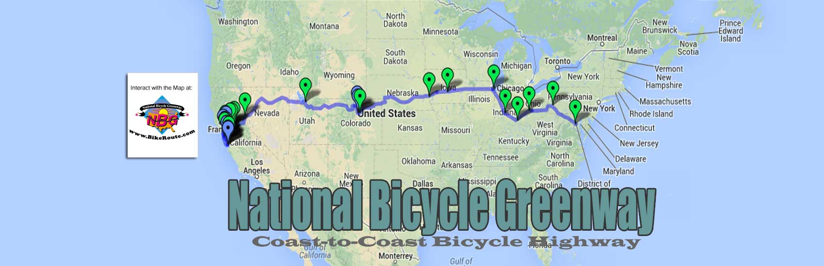
Upon compiling the results from our NBG Scouting missions, Mayors’ Ride relays, the GPS input that came our way when we had interactive maps at our site and then Google’s bike map recommendations, five years ago we made the San Francisco to Washington, DC connection that resulted, the centerpiece of our web site.
Since we are unable to build our new presence here in Indianapolis around events as a way to get our route known about and used, due to the uncertainty forced upon us by COVID-19, we have been forced to make a pretty huge redirect. Nor are we looking to replicate the magic Indianapolis Cultural Trail in our 19 other Anchor Cities. Instead, since March 2020, our efforts have been expended on plans to get our on line route from San Francisco to Washington DC marked on the ground. (Skip the underlined words below to see our present direction that has resulted from Google’s once again entering the room.)

To get NBG mile-markers placed in the middle of two-block sections on our route, we will produce a Request For Proposal for landscape desingers for the actual placement of the first 18, 4-foot tall, logo-emblazoned posts (one every ten miles) between Indianapolis and Chicago. Landscape designers specialize in designing outdoor environments, especially harmonizing parks or gardens with buildings and roads (examples of their work pictured at left). They are made up of extremely talented individuals, people who have rebuilt decaying parts of cities, rejuvenated parks, transformed waterfronts and whole business districts, etc, all over America. It is their work for example, that reinvented Indianapolis. A dying rust belt city, led by the work of Sasaki Design, as directed by Mr Greenway himself, Ray Irvin, the Indy 500 city is now known as the Greenway Capital of the Planet.
Our first leg will travel through a mix of bike paths and bypassed US highways in Indiana on USBR 35. This corridor was completed for bicyclists in 2015 (AASHTO approved it for the Indiana Dept of Transportation and Adventure Cycling). Visit Indy, the Indianapolis Convention and Visitors Bureau, had begun to promote it when COVID-19 hit. Note: We have abandoned our push to connect Indianapolis with Chicago. This is so because, while USBR 35 gets you to the shores of Lake Michigan, it is still 66 miles miles worth of roads and a smorgasbord (9) of trails and greenways east of Chicago.
Through community meetings and other means, the landscape architect firms we will have selected will professionally and convincingly, present the options available for each section as a way to help us get posts in the ground on our entire route. As they interface with local cyclists in determining their needs, they will help the people along the way see the bigger picture of the National Bicycle Greenway that these mile markers will be a part of. They will sell the vision of connectivity, economic development, health and fitness, quality of life and how we will, in time, be connecting this alignment to destinations for recreation, historic sites, education, wildlife and adventure as well as internet and infrastructure possibilities.
In doing so, the landscape architects will show all the possibilities that can exist for improved bicycle passage in each of the sections that associate with each marker. This can include everything from protected and/or separated bike lanes, to bike present signage alerts, bicycle rest areas with drinking fountains, kiosks and benches, signal timing adjustments, bike friendly curb cuts, road striping, etc. and items specific to their areas such as bike tunnels and overpasses, etc, all the way down to our minimum roadway standard of a four to six-foot wide striped bike lane. They will show them how the mile markers we foresee for their area are the key needed to to give them the bragging rights of being a part of the National Bicycle Greenway.
This will sell the first phase of our plan – of getting the route marked. Once communities agree to placement, our work to get posts in the ground will be fast. Standing apart from all the upgrades and enhancements that will follow for each associated section, HERE is a fast track schedule for the markers that will kick everything off.
The stretches that associate with each marker will then enter our system and we will formalize the upgrades all parties have agreed upon into a schedule which shows when they will take place. This will take into account when we expect funding will be made available from grants, community fund raising, government subsidies, even corporate sponsorship, etc.
Once the monies do show up for each section, calling upon their familiarity with navigating local governments and appeasing stakeholders, our landscape design architects will begin their work.
To get this ball rolling, the Requests for Proposal that NBG Director, Martin Krieg, will generate for the developers for marker placement will come back to us with handsome graphic images for what the actual posts will look like. Renderings that reflect the enhancements and upgrades that can associate with them will also be included. The landscape design teams we choose will present this information to the communities along the our route as a way to get markers and posts in the ground.
Their motivation for doing this is the windfall that will come their way as early as year four. It will be then that 40% of the logo sales on the markers will be earmarked for the upgrades and enhancements that they suggested in their initial offerings. All this is detailed in the financials that associate with the language you see here.
Also on the roadside, every mile will be marked by a nondescript 2-foot tall, black and green metal post with a number on it. Intelligent markings, these will track cell phones to an interactive computer database that shows the services, attractions and points of interest that are nearby.
Once there is cash flow from the programs (that Martin Krieg will flesh out in book form) our route will engender, these programs are –
TransAm Register Licensure | NBG Flagposts | TransAm Rider Blogs | Camino de Santiago-like pilgrimages | Corporate Sections | Greenway signage | Group use/benefit rides | Cross Country Rides by section | NBG Travel Courts, etc.
we will retrofit an abandoned 10,000 square-foot warehouse or service club center to become the Indy NBG Hub (NBG Hub description). A regional bike center with a hall for activities, bike repair facility, showers, coffee shop, the main NBG office, and etc, it is this that will be the model we look forward to establishing nationwide in all of our 19 other NBG Anchor Cities.
To help us get our route and mission to connect the coasts known about, we will hire a top-tier public relations firm. As their work drives traffic to the Hub, as well as increases the perceived value of mile-marker logo advertising and NBG memberships, it will also engage the cities along the way. It will instill community pride for these population centers to know they are to be a part of a national movement.
We will also begin a membership campaign, As a 501(c)(3) nonprofit, by the end of year five, we hope to have 225,000 general memberships all paying $20 a year. By this time, we also foresee the prospect of 2,000 Indy NBG Hub members paying $20/month/year. More than the money this will generate, we look forward to all the new talent, ideas, resources and excitement this will bring about. All this as our movement engenders a culture of like minded possibility thinkers interested in saving the planet and our collective mental and physical well-being with the bicycle.
——————————————-
Landscape design firms:
The giant in the field of landscape architecture is Alta Planning. They have developed research that has led to policy and design standard changes nationally. They also manage the only national data collection center for bike counts and surveys. With well over a hundred planners and designers, at their web site, you can see examples of work they have done in Los Angeles, Oakland, Members, Berkeley, Saint Paul, Seattle, Waterloo, and West Palm Beach, Salt Lake City, etc. Besides Alta Planning, others in this field include:
https://land8.com/30-landscape-architecture-firms-to-keep-your-eye-on
Important Note: Once again, Google has entered the room. For about two years, from 2007 to 2009, thanks to the small team of developers we had assembled in Palo Alto, CA, the epicenter of the Internet, we had begun to collect a portfolio of connecting bike routes at our site bikeroute.com. A popular feature, the traffic at it was growing at a fast rate. Our Internet Service Provider started having problems with all the traffic we were generating, when the rumor mill started heating up with talk about Google creating a bike mapping product. Even before they had anything, visits at our mapping platform began to wane. Then in 2010 when Google Bike Mapping became real, the interest in our cartographic offering vanished.
Fast forward to April 2021, as we had begun the search for funding so that Mr. Greenway himself, Ray Irvin, could begin marking the route from Indianapolis to Chicago, two important data points occurred. First, we learned that USBR 35 did not end in the Windy City. It ends in Michigan City, Indiana, 66 miles worth of roads and a smorgasbord (9) of trails and greenways away.
Then Google announced the rollout of slow maps (in case you missed it). They have figured out a way to use machine learning and artificial intelligence to do some of what we were proposing in our plan. What our NBG Scouts had done for us in year’s past, and what we were hoping we could do with anchor city to anchor city chat forums, Google will use government run data bases to harvest all of the data that will result in real time on a 24/7 basis.
This new development brings about many questions that only time can answer. Will motor vehicles crowd cyclists out on the roads that were once lightly traveled? Will touring cyclists find better routes than the ones that have been tried, trued and tested over the years? Will this shift the landscape of the businesses along the way? Etc, etc.
Having watched the burgeoning traffic at our website, almost vanish overnight when Google entered the interactive map playing field, we learned a painful lesson. When the elephant in the room, Google, decides to do something, one must observe with more than his or her eyes or ears. In other words, all the ramifications of their decision must be carefully weighed.
Fingers crossed, this could very well save us a step. In a perfect world, it could eliminate a lot of the route research we were needing to do before we committed a network of roads to mile marker signage.
For many reasons, it is imperative that we get our route marked. Besides making the National Bicycle Greenway real, logo signed markers will serve as the engine for a new economy. This is so because the revenues from the tastefully designed logo advertising that will appear every 10 miles will drive a lot of the other money making programs our route will engender. These programs are –
TransAm Register Licensure | NBG Flagposts | TransAm Rider Blogs | Camino de Santiago-like pilgrimages | Corporate Sections | Greenway signage | Group use/benefit rides | Cross Country Rides by section | NBG Travel Courts, etc.
As we wait for the dust to settle, it will be these programs that Martin Krieg will flesh out in book form. We will also promote rides from Pittsburgh to Columbus, Columbus to Indianapolis and Indianapolis to Chicago as a way to fine-tune the route we have online. Since the Nation’s Capital to Pittsburgh is a known Car Free arterial, instead of trying to get to DC, our focus has changed to getting from the former steel city to San Francisco.
Toward that end, we have already begun the work of making our on line route more accessible. As of July 2021, we have gotten our San Francisco to Washington DC map online with Ride with GPS, RWGPS is a popular and widely used bike mapping service with many connections in the bike industry and its organizations. While we have had this route at our site, BikeRoute.com since 2014, it got little attention because it was hard to work with.
You must be logged in to post a comment.